Where Your Trip Begins
There are currently nine existing access points on the Upper Cheat River Water Trail. These sites are owned and managed by public entities as well as private landowners and businesses. Please observe all posted rules and regulations and respect areas surrounding the sites to ensure continued access for future paddlers.
Access site conditions and regulations are subject to change – please visit the site kiosks and review all pertinent information. Currently, no access points along the Water Trail allow camping. Future plans include installing ADA access for several access points.
Things to keep in mind:
The Cheat River flows north. This is one of its many unique aspects, and one that continually surprises more than a few folks.
The Black Fork at Hendricks and Shavers Fork in Parsons join to form the Cheat main stem. Travelers on the Water Trail may access the main stem from either fork.
Putting in at the Hendricks foot bridge or Nursery Bottom on the Black Fork means you won’t be able to access Parkwood Lane or the U.S. 219 Bridge access points on Shavers Fork – and vice versa.
Chart your journey and view the Water Trail from above with this Interactive Map.
CAUTION – EXPERIENCED PADDLERS ONLY – The CRWT segment, Hendricks to Nursery Bottom, has been classified as “Intermediate.” This section includes fast moving water containing various rocks, holes, currents, and waves that require skillful maneuvering to avoid. Swimmers could be at risk and may require help.
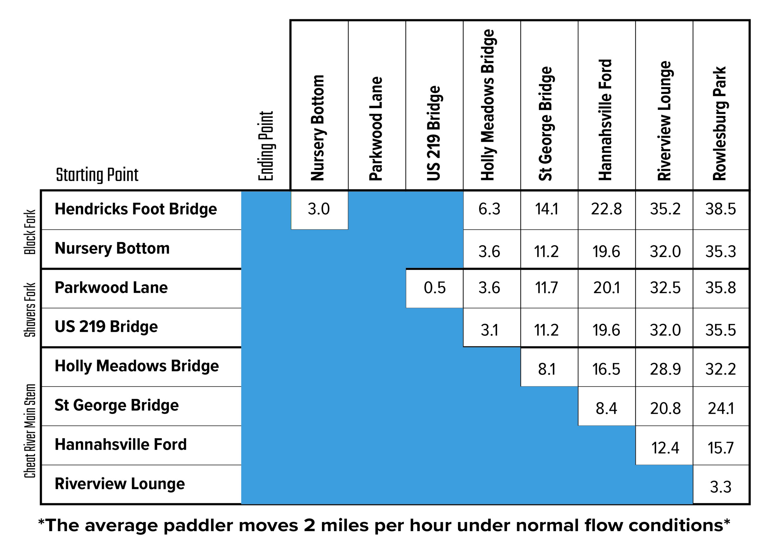
Mileage Matrix
Water Trail Sections
Hendricks to Nursery Bottom (Black Fork) – 3 miles
3 miles – 1.5 to 2 hours without breaks – Intermediate
*Caution* – Experienced paddlers only. The segment from Hendricks to Nursery Bottom has been classified as “beginner” to “intermediate” depending on water levels. This section includes fast moving water containing various rocks, holes, currents, and waves that require skillful maneuvering to avoid.
Put-in: The Hendricks Foot Bridge is on river-right. Exit WV Rt 72 onto Second Street. Cross the Allegheny Highlands Rail-Trail and follow to the swinging bridge. Park in the gravel lot off the road.
Take-Out: The Nursery Bottom access site is on river right. From US Rt. 219, turn onto Nursery Bottom Road. Park in lot on the right. Follow the foot path to the river. Beyond the gate, USFS office is open Monday-Friday from 8am to 4:30pm.
Nursery Bottom to Holly Meadows Bridge – 3.6 miles
3.6 miles – 2 hours without breaks – Easy
Put-in: The Nursery Bottom access site is on river right. From US Rt. 219, turn onto Nursery Bottom Road. Park in lot on the right. Follow the foot path to the river. Beyond the gate, USFS office is open Monday-Friday from 8am to 4:30pm.
Take-Out: The Holly Meadows Bridge access site is on river right. Exit WV Rt. 72 onto Holly Meadows Road. Cross bridge. Access is immediately after bridge on the right side of the road. Follow foot path to the river.
Parkwood Lane to US 219 Bridge (Shavers Fork) – 0.5 miles
0.5 Miles – 45 minutes without breaks – Easy
Put-In: The Parkwood Lane access site is on river left. Exit US Rt. 219 on Davis Street. Turn right on Poplar Street in 0.2 miles. Bear left at ball fields (near Civil War Trail signs) onto a dirt road. Path to river is on the left. Park in the paved lot.
Take-Out: The US 219 Bridge access site is on river left. Access is adjacent to the rail-trail bridge along US Rt. 219.
US 219 Bridge to Holly Meadows Bridge – 3.1 miles
3.1 miles – 1.5 to 2 hours without breaks – Easy
Put-In: The US 219 Bridge access site is on river left. Access is adjacent to the rail-trail bridge along US Rt. 219.
Take-Out: The Holly Meadows Bridge access site is on river right. Exit WV Rt. 72 onto Holly Meadows Road. Cross bridge. Access is immediately after bridge on the right side of the road. Follow foot path to the river.
Holly Meadows to St. George – 8.1 miles
8.1 miles – 4 hours without breaks – Easy
Put-In: The Holly Meadows Bridge is on river-right. Exit WV Rt 72 onto Holly Meadows Rd and cross bridge. Access is immediately after the bridge on the right side of the road. Follow a grassy foot path to the river.
Take-Out: The St. George Bridge is on river-right. Exit WV Rt 72 onto Location Rd, cross the bridge, and take the first right. Follow the road until it ends.
St. George Bridge to Hannahsville Ford – 8.4 miles
8.4 miles – 4.5 hours without breaks – Easy
Put-In: The St. George Bridge access site is on river right. Exit WV Rt. 72 onto Location Road. Cross the bridge and take the first right. Follow through the park until it dead ends.
Take-Out: The Hannahsville Ford access site is on river left. Exit WV Rt. 72. 0.3 miles south of Seven Islands Road. Follow Scales Limestone Road to grassy area. Park to the right of the path to the river.
Hannahsville Ford to Riverview Lounge – 12.4 miles
12.4 miles – 6.5 hours without breaks – Easy
Put-In: The Hannahsville Ford access site is on river left. Exit WV Rt. 72. 0.3 miles south of Seven Islands Road. Follow Scales Limestone Road to grassy area. Park to the right of the path to the river.
Take-Out: The Riverview Lounge access site is on river left. Enter via gravel road to the left of the Lounge. Unload and park across Rt. 50.
Riverview Lounge to Rowlesburg Park – 3.3 miles
3.3 miles – 1.5 to 2 hours without breaks – Easy
Put-In: The Riverview Lounge access site is on river left. Enter via gravel road to the left of the Lounge. Unload and park across Rt. 50.
Take-Out: The Rowlesburg Park access site is on river left. Enter the park at Buffalo Street or Catherine Street. Load and unload in the grass, park on the street or paved lot.